The Central Sierra
Our work takes place in the forests of the Central Sierra Nevada mountain range at the landscape and watershed scales (click the map below for more information).
Reading layer `TCSI_boundary' from data source
`/Users/giorap/Library/CloudStorage/Dropbox/elimia/code/wildliferesilience/website/input/TCSI_boundary.geojson'
using driver `GeoJSON'
Simple feature collection with 87 features and 2 fields
Geometry type: MULTIPOLYGON
Dimension: XY
Bounding box: xmin: -121.3203 ymin: 38.61415 xmax: -119.8765 ymax: 39.77729
Geodetic CRS: WGS 84
Reading layer `all' from data source
`/Users/giorap/Library/CloudStorage/Dropbox/elimia/code/wildliferesilience/website/input/all.geojson'
using driver `GeoJSON'
Simple feature collection with 3 features and 9 fields
Geometry type: MULTIPOLYGON
Dimension: XY
Bounding box: xmin: -121.3203 ymin: 38.61415 xmax: -119.8769 ymax: 39.77729
Geodetic CRS: WGS 84
Tahoe-Central Sierra Landscape
The Tahoe-Central Sierra (TCSI) landscape is a 1 million ha section of central California forested land. The TCSI is home to a high diversity of vegetation communities, flora, and fauna. The TCSI is an area of active research, discussion, and collaboration where state, federal, nonprofit, and private partners are working together to restore the resilience of this treasured landscape (see Resources for more information).
The TCSI spans an elevational gradient from 210 - 3400 meters. From the Central Valley to the peaks of the Sierras, the TCSI spans five distinct life zones (i.e., biotic zones). Life zones are areas that have similar abiotic conditions (e.g., climate, soils, etc.), plants and animals. In the TCSI, life zones include: foothill woodland zone, lower montane forest zone, the upper montane forest zone, the subalpine forest zone, and the alpine zone.
There are 14 dominant vegetation types in the TCSI that vary in their occurrence (Fig 1A) and density across the gradient (Fig 1B).
Considering wildlife resilience at the scale of the TCSI landscape is critical because wildlife communities occur and interact at these larger scales.
Lake Tahoe Basin
The Lake Tahoe basin is a unique combination of forest and urban communities, increasing the interest and complexity of managing forests in the area. Further, the basin supports high biodiversity, including over 1,200 species of plants and animals and has a steep elevational gradient that spans four of the five lifezones. Eight major vegetation types are common within the Lake Tahoe basin (Fig 2A) and they range in their density across the elevational gradient (Fig 2B).
When comparing the plants and animals that occur in those eight vegetation types, we see that generally, overlap in species occurrence is more common for vegetation types in the same life zone. For example, (Fig 3A) Jeffrey pine (JPN, orange circle), Sierran mixed conifer (SMC, dark green circle), and White fir (WFR, purple circle) forests are commonly found in the lower montane zone (Fig 3B) and they have high overlap in the types of plants and animal that occur in those forest types.
Given the different (and similar) species present in these forest communities, we next use our food web models and metrics to see if wildlife communities differ in composition, structure, and function. To see what this looks like see the applications page.
Caples Creek Watershed
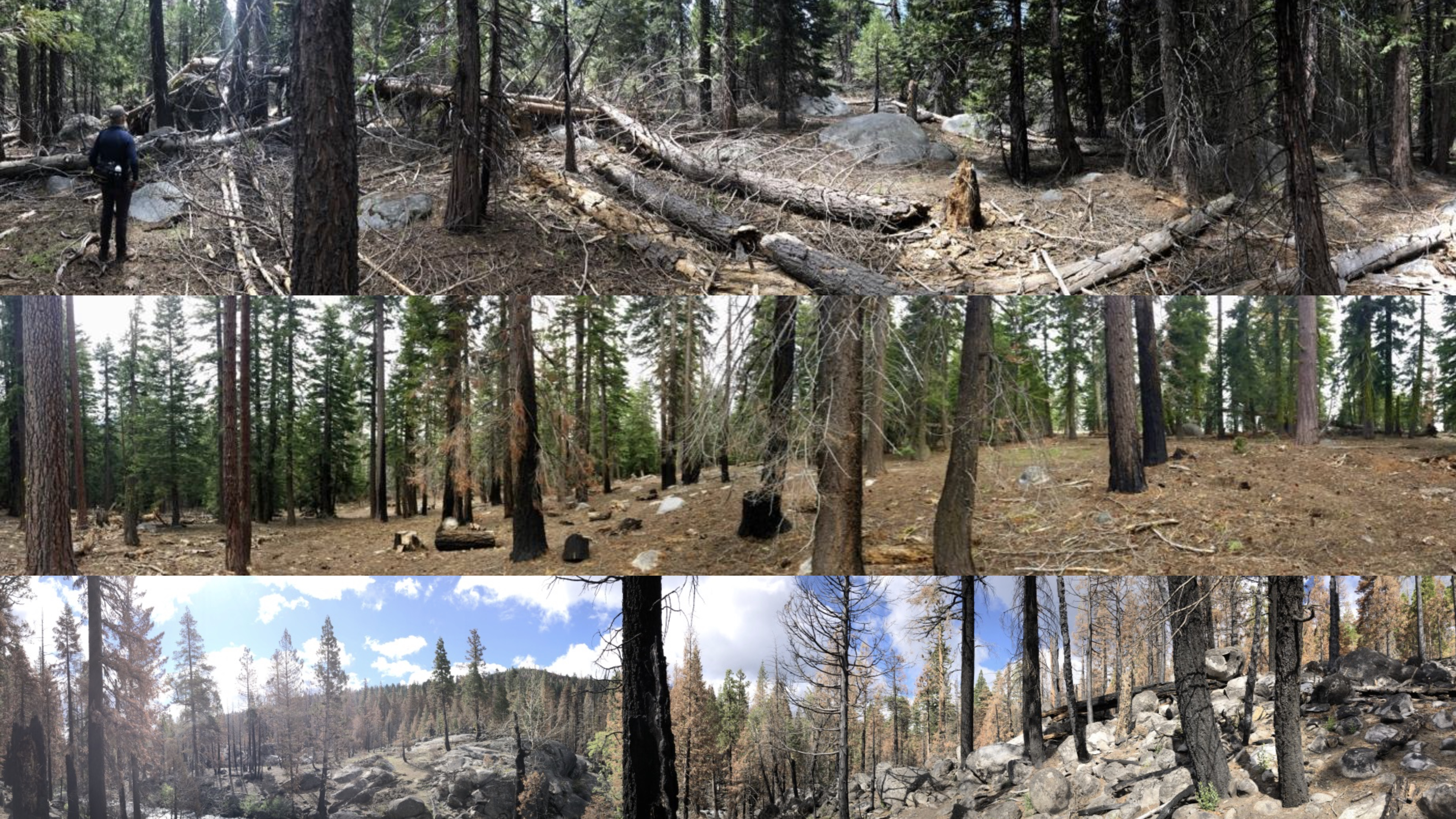
The Caples Creek Ecological Restoration Project (Caples Project) is located in the Eldorado National Forest. Since 2017, project scientists from the USDA Forest Service & California Academy of Sciences have been studying forest health and resilience in mixed conifer forests at Caples. The team has been monitoring the avian and plant response to the intentional application of fire (the 2019 prescribed Caples fire), and are comparing this to a severe wildfire (the 2021 Caldor Fire).
Our collaborative team has surveyed over 80 sites in the Caples Watershed each year gathering traditional avian point-count data as well as passive acoustic recordings, vegetation, and fuel measurements. The Caples Project provides a unique opportunity to contrast wildlife resilience metrics for forests treated with fire intentionally applied to enhance forest resilience with forests experiencing severe wildfire—providing a direct measure of the value of prescribed fire at the watershed scale and the effect of different fire severity on wildlife resilience.
Loss of resilience and its recovery: Above, shows the loss of forest resilience due to burnable biomass buildup from our study area, the Caples creek watershed (top) and impact of controlled fire just outside the watershed (middle). After the Caples Fire, a variety of burn-severities create forest heterogeneity (bottom) that may increase forest resilience to factors promoting future fires © Durrell D. Kapan, California Academy of Sciences.

